News

The World Bank has recently presented the results from Global RApid Post-Disaster Damage Estimation (GRADE) assessment. 

  • Total exposure of buildings (and contents) and infrastructure: USD 248 billion - Majority of assets in Yangon and Shan, Mandalay and Sagaing.
  • US $10.97 billion in damages (≈ 14 % of 2024/25 GDP). Residential buildings and their contents account for 45 %, infrastructure 31 %, and non residential assets 24 %.
  • GRADE results are similar to the Global Earthquake Model which estimates US$ 6.4 billion (unpublished & not detailed) in damage (for buildings only) vs. US$ 7.61 billion from GRADE (buildings and contents).
  • There is significant uncertainty in the results. While GRADE ‘best estimate’ is US$10.97 billion there is an uncertainty range of US$ 6.2 billion to US$ 15.8 billion.
  • State / Region level insights. The slides break down damage values and exposure for affected State / Regions including Yangon for economic impact.
  • Modelling shows households lacking basic water, sanitation or education suffer up to 43 % higher per capita losses, underscoring the need for inclusive recovery measures.

Download the slides.

The latest brief from the ILO highlights the negative impact of the earthquake on an already fragile labour and socioeconomic situation.

Upwards of 3.5 million workers were employed in the area directly impacted by the earthquake. This represents US$36.8 million in potential earnings lost per day (equivalent to US$9.6 billion in lost earnings per annum) if these workers are unable to work or find quality employment elsewhere.

In the short term, humanitarian emergency cash assistance is needed, ideally linked to decent employment promotion (for instance, in debris removal or infrastructure reconstruction) with fair wages that are based on the needs of workers and their families.

The ILO will continue to monitor the labour market and social consequences of the earthquake as more data become available. Future work will also provide greater insights on the medium term support measures that are needed to promote decent work and prevent abuses such as child labour or forced labour.

Download the brief.

With the monsoon season coming soon along with the likelihood of tropical cyclones, earthquake recovery planning and management must be aware of potential impacts based on historical data, especially in areas already hit hardest by the earthquake.

MIMU has compiled storm track records for Myanmar dating back to 1960 and published a summary map. For those who wish to run their own analysis, create maps, or reference the data, the GIS layer  that goes even further to 1842 is also available on the MIMU GeoNode platform.

Download the summary map.
Download the GIS layer for mapping.

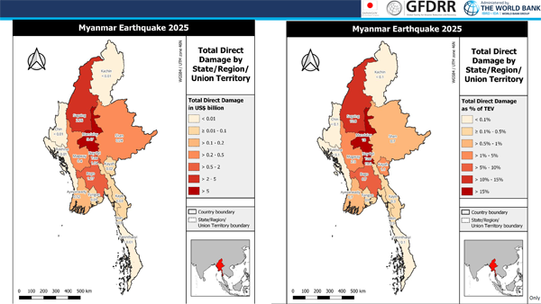
Five weeks after the devastating earthquakes struck Myanmar on 28 March, many affected communities are still in urgent need of safe shelter, health care, clean water and sanitation, cash assistance and various forms of protection support.

An early monsoon season has started with daily rains this week, exacerbating hardships for families living in tents and makeshift shelters, and increasing health risks. While needs for emergency assistance remain high, early recovery and livelihood support is vital to help affected people rebuild and restore their lives.

See the breakdown of needs, responses and activities from the latest Situation Report #5 from UNOCHA.

  • Early Recovery - Urgent support needed to restart local markets and provide affordable farming supplies in Magway, Mandalay and Sagaing to avoid delays in the upcoming monsoon planting season. With recent strong winds, Southern Shan needs support to address power outages, restore livelihoods, and provide mental health support. Over 9,000 displaced households in affected regions require immediate assistance with housing, land, and property issues + support to rebuild communities safely and inclusively. Support is also needed for safe rebuilding through technical advice, safety checks of buildings, better water and sanitation in shelters, and psychosocial services.
  • Education in Emergencies - A total of 18,000 education learning pack (ELP) kits are needed for 129 monastic schools in Mandalay, Nay Pyi Taw, and Sagaing. Also in central and north western Myanmar, there are needs for structural assessments for eight monastic schools in Mandalay and Sagaing
  • Food Security - A rapid needs assessment by Food Security Cluster (FSC) partners identified serious challenges to livelihoods and food access. About 38 per cent of surveyed communities rely on aid or support from friends and relatives to meet food needs, particularly in Magway, Mandalay, Nay Pyi Taw, Sagaing, and southern Shan. Severe food access issues were reported across all surveyed communities in Magway Region (especially in Chauk, Myothit, Taungdwingyi, and Yenaungyang townships) and in Mandalay Region (Kyaukse, Myittha, and Sintgaing townships) and Sagaing Region
  • Health – Partners report continued shortages of essential medicines, especially for common conditions such as diabetes and hypertension. Most partners rely on local pharmaceutical procurement, but there is an urgent need to conduct a market survey to identify reliable suppliers that source internationally from prequalified providers. Psychological distress is increasing in many earthquake affected areas due to delays in treatment and a critical shortage of trained mental health professionals. Limited access to water and sanitation is contributing to poor hygiene, leading to a raise in skin diseases. Delayed rubble clearance and stagnant water are creating breeding grounds for mosquitoes, heightening the risk of malaria and dengue.
  • Logistics – evaluating additional storage needs in areas affected by the earthquakes. A total of 325 cubic meters of common storage space has been made available at the Yangon warehouse, with ongoing coordination for dispatches to the Mandalay warehouse. In Mandalay, 1,000 square meters of storage space is available, including temperature controlled areas
  • Nutrition – Cluster partners have distributed essential food items – including rice, chickpeas, cooking oil, and iodized salt – to 29,472 households in Mandalay and Sagaing. Fortified biscuits were provided to 15,502 households across 8 townships in Mandalay Region, and blended food was delivered to 190 households.
  • Protection – Urgent measures are required to reduce overcrowding and mitigate gender based violence (GBV) risks. Expanded MHPSS services are needed to address trauma, stress, and anxiety resulting from conflict, displacement, and the loss of homes, livelihoods, and loved ones. Support is needed to help affected people to restore civil documentation, including key identity and legal documents that were lost during the earthquakes. Earthquake affected communities sheltering in open areas – such as public markets and private land – have reported evictions or received orders to vacate these temporary locations.
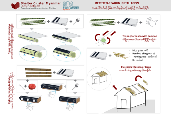
  • Shelter, NFI, CCCM – Preliminary rapid needs assessments (RNA) show that 52 per cent of houses in assessed villages across 55 townships are damaged. 74 % of the worst affected townships remain without shelter assistance, and 50 per cent lack NFI support. In most reached areas, over 75% of targeted people still need aid. Over 100 collective centres and informal sites lack proper site management systems, exposing displaced people to safety, security, and protection risks.
  • WASH – Access to safe drinking water remains a major concern. While river water is available for domestic use, drinking water is scarce for affected communities in Sagaing Region. Critical water systems, such as collapsed storage tanks, broken distribution pipes and non functional pumps require urgent technical repair and replacement to restore safe water access. Hygiene promotion, especially on the prevention of acute watery diarrhoea (AWD), must be urgently scaled up to mitigate public health risks. Rural displacement sites lack solid waste management systems, posing serious environmental and health hazards.

A recent RSIS article highlighted the increase in AI generated disinformation after the 28 March 7.7 magnitude earthquake, filling an information vacuum created by telecom shutdowns. Deepfake videos and clickbait posts misrepresented the scale and location of damage, eroding public trust and potentially exacerbating the challenges of humanitarian assistance and disaster relief. The authors stress that misinformation can delay emergency actions, and fragment coordination, especially in a conflict affected settings like Myanmar. They call for protocols to safeguard information integrity during crises, recommending the adoption of AI detection tools, dedicated counter disinformation projects, and real time regional collaboration, drawing lessons from Ukraine’s crisis communication model.

Download the article in PDF format.

Protecting sensitive data is crucial for effective humanitarian work. Sharing information helps us all better coordinate and assist those most in need. However, some information can be risky if shared improperly.

A recent one pager highlights the importance of data confidentiality and includes important pointers on how to share data safely.

Download the One-pager in English and Myanmar.

The Early Recovery (ER) Cluster was activated swiftly following the magnitude 7.7 earthquake that struck Myanmar on 28 March 2025.

Early Recovery is a strategic approach that integrates humanitarian response with long term recovery and development efforts. By applying development principles in crisis settings, it helps stabilize communities, restore essential services, and rebuild livelihoods. This ensures humanitarian action leads to sustainable recovery and greater resilience, enabling crisis affected populations to regain self reliance quickly.

Early Recovery coordination brings together humanitarian and development actors to deliver a coherent, principled emergency response, enhancing effectiveness through stronger predictability, accountability, and partnerships.

Cluster resources will be collected and featured on a newly launched Early Recovery Cluster webpage on the MIMU website.

The latest map from the United Nations Satellite Centre (UNOSAT) assess probable damage buildings focusing on a part of Monywa Township, where damage was detected using a WorldView-2 very high-resolution satellite image acquired on April 25, 2025.

UNOSAT identified 27 damaged structures and 170 potentially damaged.

This is a preliminary analysis and has not yet been validated in the field. Ground verification is encouraged, and feedback can be sent to the United Nations Satellite Centre (UNOSAT).

The Northwest Shelter/NFI Technical Working Group (TWG) in consultation with cluster members has collaboratively developed a Guidance Note on Emergency Shelter and Non-Food Items (NFI) Assistance. This aims to provide recommendations from the Northwest Shelter/NFI/CCCM Cluster regarding the provision of emergency shelter and NFI support to populations affected by the earthquake.

It outlines various assistance modalities that can be adapted according to the evolving situation on the ground and the specific needs of the affected communities.

This is a living document and will be revised and updated as necessary in response to changing conditions and new information.

Download the document from MIMU website.

Explore the Shelter/NFI/CCCM Cluster web page on MIMU.

With the monsoon season coming very soon, we have been seeing reports of rain and wind hampering response operations. At Inle Lake on 27 April, severe winds tore through Kyartaw Village near Nangpang, ripping off damaged roofs of earthquake affected homes and flattening makeshift shelters. Patheingyi Township in Mandalay Region includes seven villages on islands in the Irrawaddy River between Mandalay and Sagaing towns which reportedly faces flooding during the rainy season. The rain is also worsening road conditions, and travelling will be increasingly difficult.

An untimely rainfall warning has been issued until 4 May: rain or thundershowers are likely to be fairly widespread to widespread across the country with the likelihood of regional and isolated heavy falls.

Data from the European Centre for Medium Range Weather Forecasts (ECMWF) and other tools can be used to obtain short  and medium term weather forecasts.