Following two recent magnitude 5+ earthquakes, use MIMU’s interactive earthquake map to monitor and explore the latest and historical events since April 2007.
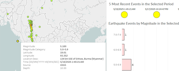
Following two recent magnitude 5+ earthquakes, use MIMU’s interactive earthquake map to monitor and explore the latest and historical events since April 2007.
Organisations have been publishing human-interest stories from the ground to highlight the devastating impact of the earthquake on communities and families, and how their efforts have been helping them recover.
Here are some stories recently published.
“We had nothing but each other” (UNICEF)
It follows Zin Mar, her disabled son Min Khant, and her elderly father in Mandalay. A one-off emergency cash transfer of 360 000 kyat (about 85 USD) gives families both flexibility and dignity to decide what they need most. More than 25 000 people have been reached so far, and registration continues in newly accessed villages.
“The quake stopped, but he hasn’t slept since” (UNICEF)
Eight-year-old Mg Pyae escaped a collapsing house but now relives the quake every night. The story explores the invisible wounds many children carry and highlights how UNICEF is rolling out psychosocial first aid, child-friendly spaces, and recreational kits so boys and girls can draw, play, and to help restore moments of joy and normalcy, ultimately for restoring hope.
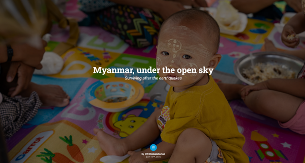
“Myanmar, under the open sky” (UNOCHA)
This photo-essay gathers voices from Mandalay and Sagaing: Daw Htar Ei (73) who lost everything she owned, including her fruit stall, twelve-year-old Nay Nay who longs to return to school, and vendors like Ma Kaythi surviving in flimsy roadside tents.
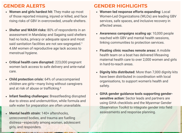
Gender in Humanitarian Action Working Group (GiHA WG) recently published the Myanmar Earthquake Gender Situation Report No. 1, based on analysis and data voluntarily shared by GiHA members and their partners, highlighting emerging gendered risks, needs and gaps to inform humanitarian action.
📝 Read more in the report.
The Shelter/NFI & CCCM National Cluster has released its Myanmar Earthquake Response Strategy (May 2025). The plan sets out a two-phase approach to assist 753,000 people. Needs have surged from 1 million to 5.2 million people requiring shelter assistance after the 28 March earthquake, which damaged or destroyed more than 40,000 homes and left many families sleeping in the open.
Phase 1 (now under way) focuses on immediate life-saving relief such as the provision of non-food items (NFI) and emergency shelter over the first three months; Phase 2 starts immediately after Phase 1 and shifts to life-sustaining response such as shelter repairs and dignified transitional solutions before the monsoon. The strategy stresses DRR, gender and protection mainstreaming, and calls for urgent funding and enhanced coordination to scale up the response.
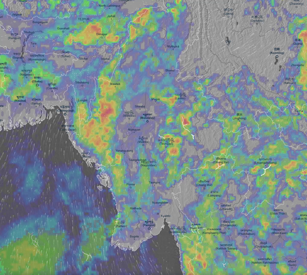
The monsoon has reached Myanmar this week, and a weather advisory warns of scattered to widespread rainfall, including isolated heavy downpours, across several regions and states between 14 – 20 May.
These rains can have adverse effects on earthquake recovery and response efforts, and they pose added challenges for affected communities still sleeping in the open, as noted above.
The Market Analysis Unit (MAU) previously released the report from the Rapid Market Assessment (RMA) conducted in 25 markets soon after the earthquake from April 1-10. This latest iteration is even more comprehensive and covers 59 earthquake/non-earthquake townships throughout 9 states/regions based on data collected from April 21-29.
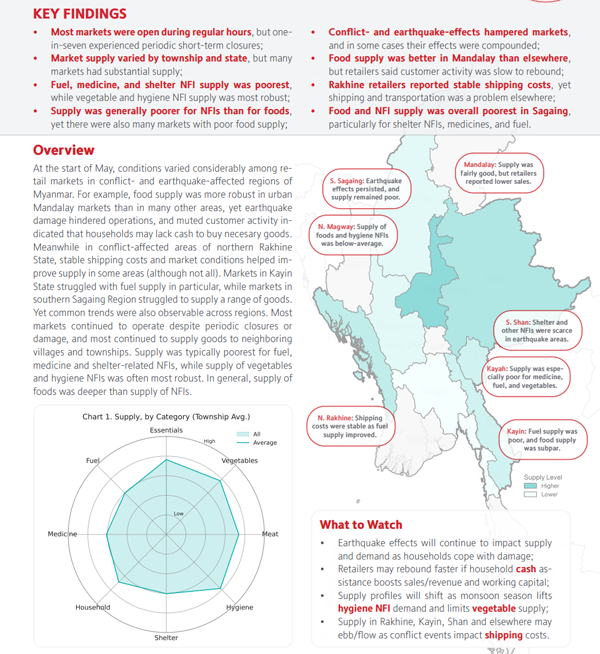
The Market Analysis Unit is an independent project that provides donors, humanitarian responders, development practitioners and private sector actors in Myanmar with data and analysis to better understand the impacts of market developments, conflict and other crises on household purchasing power, supply chains, financial services, and labour markets.
The results of satellite-based remote sensing analyses from UNOSAT, including ground photos for validation, have been compiled into an interactive web map. Initially released last month, this map has recently been updated to include UNESCO-listed sites.
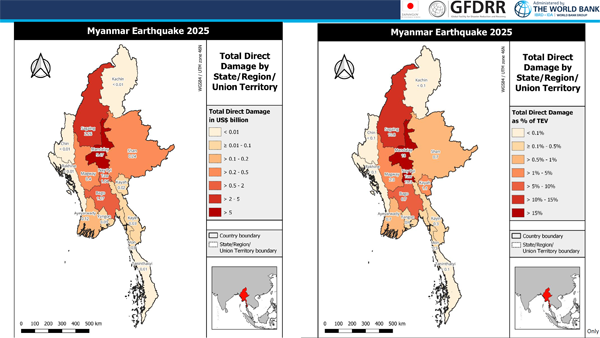
The World Bank has recently presented the results from Global RApid Post-Disaster Damage Estimation (GRADE) assessment.
The latest brief from the ILO highlights the negative impact of the earthquake on an already fragile labour and socioeconomic situation.
Upwards of 3.5 million workers were employed in the area directly impacted by the earthquake. This represents US$36.8 million in potential earnings lost per day (equivalent to US$9.6 billion in lost earnings per annum) if these workers are unable to work or find quality employment elsewhere.
In the short term, humanitarian emergency cash assistance is needed, ideally linked to decent employment promotion (for instance, in debris removal or infrastructure reconstruction) with fair wages that are based on the needs of workers and their families.
The ILO will continue to monitor the labour market and social consequences of the earthquake as more data become available. Future work will also provide greater insights on the medium term support measures that are needed to promote decent work and prevent abuses such as child labour or forced labour.
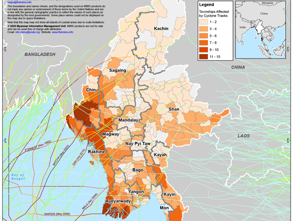
With the monsoon season coming soon along with the likelihood of tropical cyclones, earthquake recovery planning and management must be aware of potential impacts based on historical data, especially in areas already hit hardest by the earthquake.
MIMU has compiled storm track records for Myanmar dating back to 1960 and published a summary map. For those who wish to run their own analysis, create maps, or reference the data, the GIS layer that goes even further to 1842 is also available on the MIMU GeoNode platform.
Download the summary map.
Download the GIS layer for mapping.