News

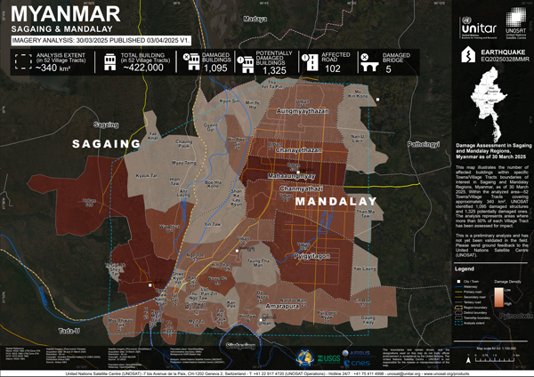
The United Nations Satellite Centre (UNOSAT) has released its initial assessment of structures potentially damaged by the recent Sagaing Earthquake. Using very high-resolution Pleiades satellite imagery, UNOSAT analysed areas in the Sagaing and Mandalay Regions. Here is a brief summary of the results released so far:

  • Within 52 Towns/Village Tracts (~340 km²) covering parts of Sagaing and Mandalay, UNOSAT identified 1,095 damaged structures and 1,325 potentially damaged structures.
  • Within a specific ~30 km² area analysed in Sagaing Township, UNOSAT identified 233 damaged structures and 557 potentially damaged structures.
  • Within an analysed area of ~60 km² covering Mahaaungmyay, Chanmyathazi, and Chanayethazan Townships, UNOSAT identified 509 damaged structures and 284 potentially damaged structures.

Please Note: This is a preliminary analysis based on satellite imagery and has not yet been validated in the field. UNOSAT welcomes ground feedback to refine the assessment.

Kyle Bradley and Judith A. Hubbard shared their analysis of the rupture in the latest article on Earthquake Insights.

The updated USGS slip model shows an interesting pattern along the fault rupture. The southern section of the Myanmar fault seems to have slipped only in the upper several kilometers, for a length of over 100 kilometers. This is a bit unexpected, because larger slip usually happens on the deeper part of the fault, and smaller slip happens close to the surface.

One hypothesis is that earthquakes in 1929 and 1930 might have ruptured the deeper parts of this southern fault segment, leaving the shallow section stressed but locked. The powerful M7.7 event, tearing southwards, may have finally “unzipped” this shallow, waiting portion.

Important Note: These slip models, yet powerful, rely on interpretations based on available data (which is sparser for Myanmar than for some other recent major quakes). Different analyses might show variations.

  • Maps from the latest HDP Nexus 5W Round (February 2025): Released today, these maps offer a very recent snapshot of humanitarian, development, and peace activities on the ground before the earthquake, providing a pre-disaster baseline.
  • MIMU has compiled the list of 91 townships that experienced earthquake intensity 6.0 and above, based on USGS’s Modified Mercalli Intensity (MMI) data. (Download here)

Please let us know if you have any questions or additional information that we should include. Thank you for your continued collaboration in these trying times.

One year ago, we produced a map showing the epicentres of earthquakes in Myanmar over the last 100 years (data as of December 2023). An updated version is now available, including the latest seismic activity data as of February 2025.

These resources can be explored in the MIMU’s dedicates page for earthquake emergency preparedness and response.

Explore the trends in food and commodity prices, as well as market conditions in Rakhine State, Shan State, Kayin State, Magway, and Sagaing Regions, in the latest reports released today on the Market Analysis Unit (MAU) page.

The Market Analysis Unit is an independent project that provides donors, humanitarian responders, development practitioners and private sector actors in Myanmar with data and analysis to better understand the impacts of market developments, conflict and other crises on household purchasing power, supply chains, financial services, and labour markets.

Tomorrow is World Water Day. To mark this day, we’d like to bring your attention to WASH cluster page on MIMU website.

The Water, Sanitation and Hygiene (WASH) Cluster was activated in Myanmar together with the Health and the Shelter clusters at the end of December 2012 so as to strengthen the humanitarian emergency response capacity for crises in Kachin and Rakhine. The National WASH Cluster is led by UNICEF with collective participation of all WASH actors, with WASH Sub-clusters formed in Rakhine and Kachin. Specific activities of the WASH Cluster are (1) Supporting WASH service delivery, (2) Informing strategic decision-making of the Humanitarian Country Team for the humanitarian response, (3) Planning and strategy development, (4) Advocacy, (5) Monitoring and reporting the implementation of the WASH cluster strategy and results, and recommending corrective actions where necessary, and (6) Contingency planning/preparedness activities in areas and situations where there is a high risk of recurring or significant new disaster.

In the Humanitarian Needs and Response Plan Myanmar 2025, WASH cluster is targeting 2.2M people out of 6.9M people in need.

Gallup recently published the World Happiness Report 2025 to mark the International Day of Happiness. Here are some key insights for Myanmar:

  • For overall happiness / life evaluation, Myanmar ranks 126 out of 147, the lowest among ASEAN countries.
  • However, Myanmar ranks 2nd globally in generosity, with 80.1% of respondents reporting donations to charity within the past month.
  • Myanmar scores low in terms of social support from family and friends, GDP per capita, and especially in the freedom to make life choices.

Explore more insights in the World Happiness Report and dashboard page for Myanmar.

The dedicated Gender Sector page on MIMU website disseminates resources and data on women and girls, supporting gender-related humanitarian and development activities, and promoting advocacy on gender issues. In addition, we are also hosting the Protection from Sexual Exploitation and Abuse (PSEA) webpage, as well as a dedicated page for the Gender in Humanitarian Action Working Group (GiHA WG), launched in October 2024.

Gender-focused programmes are included in the MIMU HDP Nexus 5W. In August 2024’s 5W round, 1,082 reported activities related to gender and gender-based violence were recorded, accounting for around 1% of all reported activities.

MIMU trainings also support professional women in humanitarian and development careers. We paid careful attention to promoting gender equality and opportunity in participant selection: of the 372 technical trainees in 2024, 208 were women.

Through data and information management practices, we are working to promote a better understanding of the challenges facing women and girls in Myanmar, while also highlighting the need for more comprehensive sex-disaggregated data.

MIMU Baseline Dataset has recently been updated.

It now includes data from 2024 international reports and dashboards such as the UNSD Statistical Yearbook, ADB Key Indicators for Asia and the Pacific, and the World Bank’s World Development Indicators dashboard. Over 100 SDG-related indicators have been added, drawn primarily from the UNSD Myanmar SDG Country Profile dashboard.

You can now access the Excel dataset containing 384 indicators from 296 sources, covering the period 2014–2024. For a better understanding of these indicators, we recommend reviewing the metadata file. An updated Baseline Dataset Dashboard is also available for a more interactive, user-friendly experience.

If you need sector- or region-specific information, specialized datasets are provided. You can also request further customized data via our request form.

International Campaign to Ban Landmines (ICBL) has produced the annually updated landmine monitor report for Myanmar and is now available in both English and Myanmar languages.

For the first time, Myanmar has more casualties due to landmines than any other country in the world in the previous calendar year, with at least three casualties every day.

Casualties and contamination are reported in all states and regions, except Nay Pyi Taw. Casualties were recorded in 134 townships, and at least 190 (57%) townships are contaminated.

There is a significant increase in contamination and casualties, as well as hazards posed by explosive remnants of war (ERW), with one ERW casualty every three days.

Explore the report for more insights.